Ireland is preparing for a significant weather event as Storm Goretti sweeps in from the Atlantic. Met Éireann has issued Status Yellow snow and rain warnings for key southern counties, with rain turning to sleet and snow, especially in higher areas. The storm’s arrival brings hazards including hazardous travel conditions, icy roads, spot flooding, and poor visibility for drivers, pedestrians, and emergency services.
This blog explains the situation in full detail, covering forecasted weather, likely impacts, safety advice, county‑by‑county effects, sea and marine risks, local responses, preparation tips, and what to expect after the storm passes.
What Is Storm Goretti and Why Is It Affecting Ireland?
Storm Goretti is a deep low‑pressure system that formed out in the Atlantic and is moving northeast toward Ireland and the UK. As it approaches, it draws in moisture from the ocean and clashing air masses. Warm, wet air meets cold continental air over Ireland, causing rain and snow to develop in places.
Unlike ordinary rain events, storms like Goretti bring a combination of heavy precipitation, wind, and rapid weather changes. For Ireland, the track of the storm means the south and southeast regions are most at risk of seeing rain turning to snow and sleet on Thursday afternoon and evening.
What the Yellow Warnings Mean
Met Éireann has placed a Status Yellow weather warning for counties Cork, Kerry, Waterford, and Wexford. This warning is active from 12:00 noon to 20:00 (8pm) on Thursday and highlights the likelihood of:
- Heavy rain that could lead to localized flooding
- Rain turning to sleet and snow in elevated areas
- Snow accumulations possible in parts of the warning zone
- Icy road surfaces and poor visibility
- Hazardous travel for cars, buses, and pedestrians
The warning aims to alert people to prepare and to avoid unnecessary travel during peak storm hours.
How the Weather Will Change Through the Day
Morning: Quiet But Cloudy Start
Before the storm arrives, Ireland will see a mostly dry and cloudy morning. Temperatures are mild compared with previous cold snaps, but the atmosphere is unstable and ready to shift rapidly once Storm Goretti’s system moves closer.
Midday to Afternoon: Rain First, Then Frosty Change
By midday, rain will spread over the southern counties. In many places, this rain will be heavy at times. As temperatures dip later in the afternoon, the rain will begin to turn to sleet and snow in places, especially in higher elevations such as the Comeragh Mountains in Waterford or uplands in Cork and Kerry.
Evening: Snow and Sleet Become More Likely
Between late afternoon and early evening, snow and sleet become more frequent in the warning zones. Lower ground may still see rain, but hills and higher terrain will experience snow. This mix of precipitation can create very slippery surfaces and poor driving conditions.
Which Irish Counties Are Most Affected?
Here’s a closer look at the counties under the yellow warning and what they are likely to experience:
Cork
Cork is at the western edge of the forecasted storm track. Heavy rain is expected early, especially near the coast and around Cork Harbour. Inland and at higher elevation, rain is likely to mix with sleet and snow as temperatures drop. These conditions create a risk of flooding on minor roads and icy patches, especially after dark.
Kerry
Kerry’s mountains — including the MacGillycuddy’s Reeks — will see the earliest build‑up of snow as elevation spikes. Snow may accumulate on higher slopes, and winds may drive sleet onto lower roadways. Travel through mountain passes may be especially difficult.
Waterford
Waterford will feel the rain first, with a clear chance that precipitation will turn to snow further inland. The combination of spot flooding and falling temperatures will test road crews and motorists alike. Bridges and shaded road sections may freeze before open roads.
Wexford
Wexford sits between the other counties and will see a rain‑to‑snow transition similar to Waterford. Coastal winds may push moisture inland, extending the time rain persists before changing over to sleet and snow.
What Conditions Could Look Like on the Ground
Storm Goretti’s impact will not be uniform. Conditions in one town might differ just a few miles inland. Here’s what people might see:
Heavy Rain and Flood Pockets
The rain could concentrate in towns near rivers and valleys. Localized flooding may occur where drains are overwhelmed. Drivers and cyclists should watch for standing water on roads.
Snow in Elevated Areas
Uplands will see sleet and snow changeovers earlier and stay snowy longer. Snow is most likely above 200–300 meters elevation, but in short bursts it could reach lower levels if temperatures dip quickly.
Icy Patches After Rain and Snowfall
Where rain falls on cold surfaces or where snow melts then refreezes, roads could become icy. Black ice is a hazard because it can be hard to see, especially under street lighting or at dusk.
Poor Visibility and Driving Conditions
Heavy rain, sleet, and snow can reduce visibility. Motorists should use headlights, slow down, and keep extra distance between vehicles. Pedestrians should stay visible and wear reflective clothing.
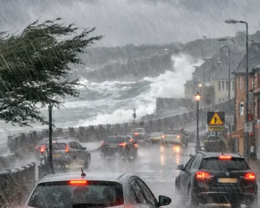
Marine and Coastal Risks
In addition to the inland rain and snow, sea and coastal conditions will also become rough. Beaufort scale winds near the coast could make marine conditions dangerous for small craft. This includes:
- Strong gusts along the south coast
- High waves breaking onto jetties and low‑lying areas
- Spray and wave overtopping at points such as Cork Harbour
Fishermen and boat owners should secure vessels and avoid unnecessary trips offshore.
Impact on Daily Life and Travel
Storm Goretti could disrupt daily routines and travel plans.
Road Travel
Road conditions may become treacherous by midday and evening. Snow and ice atop wet roads make braking distances longer. Many local councils and road crews will grit main routes, but secondary roads may not be treated immediately.
Public Transport
While rail services across southern Ireland are less at risk than heavy snow regions, even rain‑to‑snow transitions can slow services. Buses may be delayed due to road conditions. Travelers should check schedules before departure.
Air Travel
Air travel in and out of Ireland could see delays if strong winds and heavy precipitation affect airport operations. Cork Airport, in particular, may experience reduced visibility, while other airports monitor approaching weather conditions.
School and Work Schedules
Parents and workers should watch local updates. If conditions deteriorate midday, some schools or workplaces may adjust schedules or encourage remote work to reduce risk.
Safety Tips for Residents and Travelers
If you’re in the warning area, here are some practical steps you can take:
- Check Weather Updates Regularly – Forecasts change, and Met Éireann may update warnings with new timings or alerts.
- Avoid Unnecessary Travel – Especially during peak storm hours from noon to evening.
- Drive Slow and Stay Alert – Keep headlights on and increase following distance.
- Carry Emergency Supplies – Warm clothes, snacks, water, and a fully charged phone are essential.
- Check on Vulnerable Neighbors – Elderly or isolated people may need help with snow or errands.
- Secure Outdoor Items – Loose garden objects can become projectiles in heavy winds.
What Happens After the Storm?
Once Storm Goretti moves eastward by late Thursday night or Friday morning:
- Clearer skies may return for many parts of the country
- Temperatures may stay low, which means lingering ice on roads and paths
- There could still be showers and wintry flurries at times
- Some rural or higher areas may keep snow cover for longer
This means the hazard does not end instantly when the warning expires — cold surfaces can remain slippery, and thaw‑freeze cycles create ongoing risk through the next day.
Conclusion: Stay Prepared and Stay Safe
Storm Goretti’s reach into Ireland is a reminder that Atlantic storms can impact both weather and daily life, even beyond the UK. Southern counties including Cork, Kerry, Waterford, and Wexford are at the front line of this event with rain, sleet, and snow likely throughout Thursday afternoon and evening.
By staying informed, following guidance from Met Éireann, and preparing ahead, residents and visitors can reduce risk and navigate this storm with confidence.